Beijing deploys drones for South China Sea surveillance
(SCMP) – A network of drones has been deployed by Beijing to watch over the islands and reefs of the disputed South China Sea.
The network, run by the Ministry of Natural Resources, covers the uninhabited, hard-to-reach islands as well as the vast open waters of the area, according to the ministry’s South Sea Bureau.
The drone communication chain has “extremely enhanced our dynamic surveillance of the South China Sea, and expanded our reach to the high seas”, the bureau said on its official website.
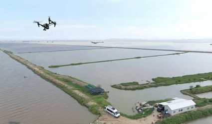
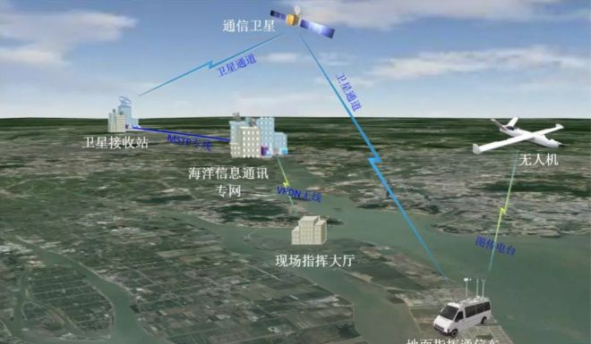
The air-land system consists of numerous unmanned aerial vehicles (UAVs) carrying high-definition cameras, road-mobile communication vehicles which act as transmission relay stations, as well as a satellite-based maritime information communication network, according to the bureau.
The light drones are intended to supplement China’s satellite remote sensing system – which is often affected by cloudy weather in the area – with higher definition, multi-angle, and real-time images.
The communication vans can be driven or ferried to places that lack a land-based communication station and receive signals sent by the drones. The signals can then be uploaded to the satellite network as still images or live streams, to be displayed thousands of kilometres away at the bureau’s command headquarters in the southern province of Guangdong.
“The system has been used in maritime administration including to inspect waters for suspicious signs, investigate historical problem sites, and monitor the sea and islands in real time,” the bureau said.
“It will play a significant role in cases of disaster observation and emergency response, such as oil spill accidents or red tide algal outbreaks.”
China claims most of the resource-rich South China Sea, which is also one of the world’s busiest trading routes, but there are competing and overlapping claims to the area by Vietnam, the Philippines, Malaysia and Brunei.
The drone network is China’s latest assertion of its authority over the region, following the establishment of military outposts on seven artificial islands it built in the disputed Spratly archipelago.
China is also launching the Hainan satellite constellation system – expected to be completed by 2021 – for real-time daily monitoring of traffic in the South China Sea. The system will include six optical satellites, two hyperspectral satellites and two radar satellites.
Beijing has also established weather radars, maritime observation, and environmental monitoring stations, reinforcing its sovereignty and providing “public goods” to other users of the sensitive area.